
Αυτός είναι ο "καλός" χιονιάς , που πάνω στις ψυχρές και πολικής προέλευσης αέριες μάζες που έχουν εισβάλει στη χώρα μας, έρχεται ένα βαρομετρικό χαμηλό απο τις ακτές της Βόρειας Αφρικής και τροφοδοτεί με πολύ υγρασία σχεδόν όλη την χώρα (κυρίως τα ανατολικά και Βόρεια ) και ότι πέφτει είναι πλέον χιόνι.
Ιδιαίτερη προσοχή στις ήδη επιβαρυμένες περιοχές.
Aπό την αρχή της εκπομπής έως το 13' λεπτό απο την εκπομή της ΕΡΤ "Αίθουσα σύνταξης"
http://webtv.ert.gr/katigories/enimerosi/09ian2017-ethousa-sintaxis/
Αναλυση και στο δελτίο καιρού του Mega
Το σπάνιο φαινόμενο που "αχνίζει" η θάλασσα στο Ναύπλιο και αλλού .
Ευχαριστώ τους φίλους που το διάβασαν και το επαναλαμβάνω ;
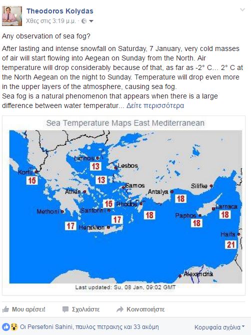
Any observation of sea fog?
After lasting and intense snowfall on Saturday, 7 January, very cold masses of air will start flowing into Aegean on Sunday from the North. Air temperature will drop considerably because of that, as far as -2° C… 2° C at the North Aegean on the night to Sunday. Temperature will drop even more in the upper layers of the atmosphere, causing sea fog.
Sea fog is a natural phenomenon that appears when there is a large difference between water temperature and temperature of the mass of air above it. When vapour appears, it quickly condenses in the cold air, creating fog
Water temperature in the North Aegean still ranges between +13° C… +15° C and between +15° C… +17° C in the central and south parts of the Aegean. This way the contrast of temperatures will be enough for intensive sea fog to appear.
Sea smoke mainly caused by evaporation. This type of fog is rather shallow and lies generally below 10m in height from the surface and is locally restricted to places with large temperature differences with the air colder than the water.
