
Όλοι γνωρίζουμε οτι η έγκαιρη πρόγνωση των καιρικών αλλαγών, είναι απαραίτητη τις περισσότερες φορές για λόγους προστασίας του ανθρώπινου πληθυσμού καθώς και για τη λήψη μέτρων ασφαλείας και επιβίωσης. Πριν από 4 περίπου χρόνια στη 17η σύνοδο του Παγκόσμιου Μετεωρολογικού Οργανισμού (WMO) στη Γενεύη όπου αποφασίστηκε η τυποποίηση των πληροφοριών περί επικινδυνότητας και ακραίων γεγονότων, συμπεριλαμβανομένης της δημιουργίας και υιοθέτησης ενός συστήματος εκχώρησης ενός μοναδικού αναγνωριστικού σε κάθε συμβάν, έτσι ώστε τα γεγονότα να καταγραφούν και να συνδεθούν με συγκεκριμένες ζημιές και απώλειες. Ο νέος Οδικός Άξονας για τα ακραία φαινόμενα και ενός ενιαίου συστήματος προειδοποιήσεων θα ολοκληρωθεί το 2025 και φέτος στην Γενεύη η Εθνική Μετεωρολογική Υπηρεσία ως επίσημος φορέας του κράτους θα μετάσχει στις διαβουλεύσεις για τον νέο σχεδιασμό των Υπηρεσιών Καιρού ειδικά στις περιπτώσεις έντονων και ακραίων φαινομένων με επέκταση του συστήματος Προειδοποιήσεων Meteoalarm
Παρακάτω σας παραθέτσω περιληπτικά και με αλφαβητική σειρά τον επίσημο κατάλογο των επικίνδυνων και ακραίων φαινομένων με βάση τις αποφάσεις του Διεθνούς Οργανισμού. Στον συγκεκριμένο κατάλογο περιλαμβάνονται φαινόμενα που σχετίζονται με 1) Τον καιρό το κλίμα και το νερό 2) Τους γεωλογικόύς παράγοντες 3) Τα φαινόμενα Διαστημικού Καιρού
I. Weather, Climate and Water (alphabetical order)
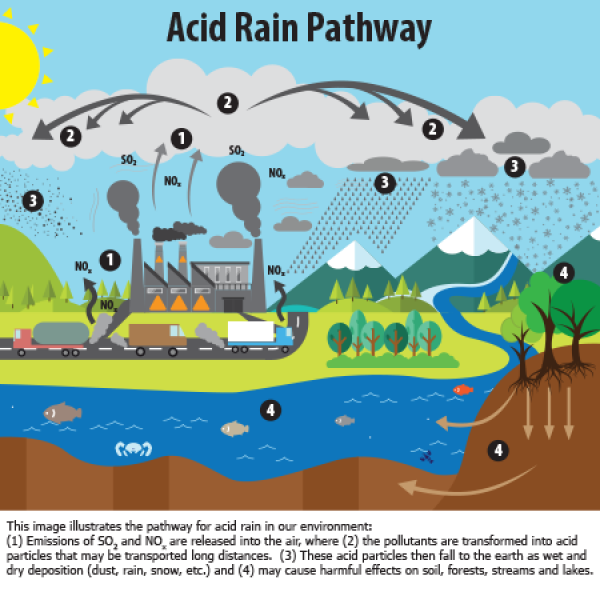
Acid rain
Deposition of acid substances by precipitation, resulting from the long-range atmospheric transport of pollutants which enhanced environmental acidification when reaching the Earth's surface (source: CCL TT-DEWCE).
Annual flood
Highest peak discharge in a year. (2) Flood level which has been equaled or exceeded once a year (source: International Glossary of Hydrology, WMO-No. 385).

Avalanche
Mass of snow and ice falling suddenly down a mountain slope and often taking with it earth, rocks and rubble of every description (source: International Meteorological Vocabulary, WMO-No. 182).
Black carbon
Operationally defined aerosol species based on measurement of light absorption and chemical reactivity and/or thermal stability. Black carbon is formed through the incomplete combustion of fossil fuels, biofuel, and biomass, and is emitted in both anthropogenic and naturally occurring soot. It consists of pure carbon in several linked forms. Black carbon warms the Earth by absorbing heat in the atmosphere and by reducing albedo, the ability to reflect sunlight, when deposited on snow and ice (source: Integrated Assessment of Black Carbon and Tropospheric Ozone, WMO-No. 1073).
Blizzard
Violent winter storm, lasting at least 3 hours, which combines below freezing temperatures and very strong wind laden with blowing snow that reduces visibility to less than 1 km (source: International Meteorological Vocabulary, WMO-No. 182).

Brown clouds
Elevated black carbon concentrations in areas with high solar radiation are a major contributor to the so-called brown clouds covering large regions, for instance in Asia. Brown clouds have led to dimming of the Earth’s surface, warming of the atmosphere and perturbation of the hydrological cycle, possibly affecting the monsoon (source: The carbonaceous aerosol – a remaining challenge, WMO Bulletin, Volume 58(1) – January 2009).
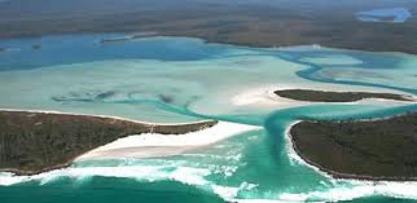
Coastal flood
Storm surges and high winds coinciding with high tides are the most frequent cause of this type of flooding. The surge itself is the result of the raising of sea levels due to low atmospheric pressure. In particular configurations, such as major estuaries or confined sea areas, the piling up of water is amplified by a combination of the shallowing of the seabed and retarding of return flow. Major deltas such as the Mississippi and Ganges are prone to this type of flooding when affected by hurricanes (cyclones). Another sensitive area is the southern North Sea in western Europe as a result of particular tracks of winter depressions. If the surge takes place near the mouth of a river issuing into the sea, the river flow will be obstructed due to the surge, resulting in severe flooding over and near the coastal areas. Tsunamis resulting from sub-seabed earthquakes are a very specific cause of occasionally severe coastal flooding (source: Manual on flood forecasting and warning, WMO-No. 1072).
Cold wave
Marked cooling of the air, or the invasion of very cold air, over a large area (source: International Meteorological Vocabulary, WMO-No. 182). A marked and unusual cold weather characterized by a sharp and significant drop of air temperatures near the surface (Max, Min and daily average) over large area and persisting below certain thresholds for at least two consecutive days during the cold season (source: CCL TT-DEWCE)
Downburst
Violent and damaging downdraught reaching the surface, associated with a severe thunderstorm (source: International Meteorological Vocabulary, WMO-No. 182).
Drought
Prolonged absence or marked deficiency of precipitation. Period of abnormally dry weather sufficiently prolonged for the lack of precipitation to cause a serious hydrological imbalance (source: International Meteorological Vocabulary, WMO-No. 182).A marked unusual period of abnormally dry weather characterized by prolonged deficiency below a certain threshold of precipitation over a large area and persisting for timescales longer than a season (source: CCL TT-DEWCE)
Dry spell
Period of abnormally dry weather. Use of the term should be confined to conditions less severe than those of a drought (source: International Meteorological Vocabulary, WMO-No. 182). A period of unusually dry conditions (*) of at least five consecutive days with daily precipitation less than 1mm.(*) i.e. to exclude usually dry periods, such as during dry seasons in arid or semi-arid areas (source: CCL TT-DEWCE)
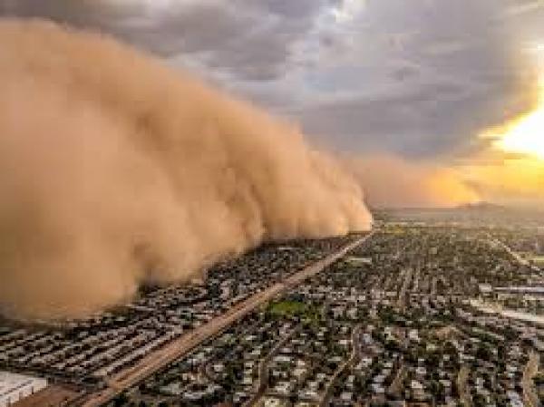
Dust storm
Particles of dust energetically lifted by a strong and turbulent wind. Dust storms are usually associated with hot, dry and windy conditions, especially just ahead of vigorous cold fronts that can be cloud free. Dust particles typically have a diameter of less than 0.08 mm and consequently can be lifted to far greater heights than sand (source: Aerodrome Reports and Forecasts, A Users’ Handbook to the Codes, WMO-No. 782).
Estuarine flood
Estuaries are inlet areas of the coastline where the coastal tide meets a concentrated seaward flow of fresh water in a river. The interaction between the seaward flow of river water and landward flow of saline water during high tides may cause a build-up of water or inland-moving tidal bore. Frequently, the funnel shape characteristic of many estuaries causes an increase in high water levels in the upper, narrowing reaches of the associated river. These types of floods are mostly experienced in deltaic areas of rivers along the coasts, for example the Mouths of the Ganges. They are more frequent and less severe in terms of inundated depth and area than flooding caused by storm surges (source: Manual on flood forecasting and warning, WMO-No. 1072).
Extra-tropical cyclone
Low-pressure system which develops in latitudes outside the tropics (source: International Meteorological Vocabulary, WMO-No. 182).
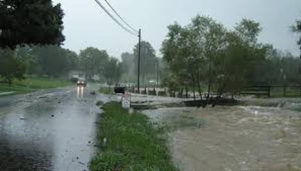
Flash flood
A flood that rises quite rapidly with little or no advance warning, usually as a result of an intense rainfall over a small area or, possibly, an ice jam, a dam failure, etc. (source: International Meteorological Vocabulary, WMO-No. 182).
Flood
The overflowing by water of the normal confines of a stream or other body of water, or the accumulation of water by drainage over areas which are not normally submerged (source: CCL TT-DEWCE).
Flooding
Overflowing by water of the normal confines of a watercourse or other body of water. Accumulation of drainage water over areas which are not normally submerged. Controlled spreading of water for irrigation (source: International Glossary of Hydrology, WMO-No. 385).
Fluvial (riverine) flood
Fluvial flooding occurs over a wide range of river and catchment systems. Floods in river valleys occur mostly on flood plains or wash lands as a result of flow exceeding the capacity of the stream channels and spilling over the natural banks or artificial embankments. Flash floods are often more damaging, occurring in narrow, steep and confined valleys, characterized as the name implies by the rapidity of formation following rainfall and high flow velocities. The rapidity makes them particularly dangerous to human life (source: Manual on flood forecasting and warning, WMO-No. 1072).
Fog
Suspension of very small, usually microscopic water droplets in the air, generally reducing the horizontal visibility at the Earth's surface to less than 1 km (source:International Meteorological Vocabulary, WMO-No. 182).
Gale
Wind with a speed between 34 and 40 knots (Beaufort scale wind force 8) (source: International Meteorological Vocabulary, WMO-No. 182).
Hail
Precipitation of either transparent, or partly or completely opaque particles of ice (hailstones), usually spheroidal, conical or irregular in form and of diameter very generally between 5 and 50 millimeters, which falls from a cloud either separately or agglomerated into irregular lumps (source: International Meteorological Vocabulary, WMO-No. 182).

Haze
Suspension in the atmosphere of extremely small, dry particles which are invisible to the naked eye but numerous enough to give the sky an opalescent appearance (source: International Meteorological Vocabulary, WMO-No. 182).
Heatwave/heat wave
Marked warming of the air, or the invasion of very warm air, over a large area; it usually lasts from a few days to a few weeks (source: International Meteorological Vocabulary, WMO-No.182).A marked unusual hot weather over a region persisting at least two consecutive days during the hot period of the year based on local climatological conditions, with thermal conditions recorded above given thresholds (source: CCL TT-DEWCE)
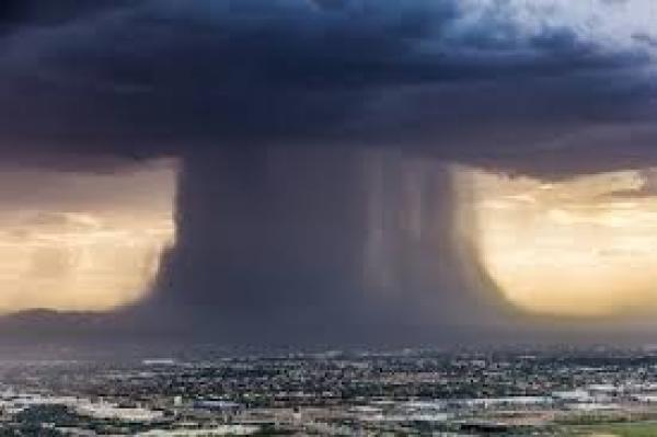
Heavy precipitation
A marked precipitation event occurring during a period of time of 1h, 3h, 6h, 12h, 24h or 48 hours with a total precipitation exceeding a certain threshold defined for a given location (source: CCL TT-DEWCE)
Heavy rain
Rain with a rate of accumulation exceeding a specific value, e.g. 7.6 mm h|~|-1 (source: International Meteorological Vocabulary, WMO-No. 182).

Hoar frost
Deposit of ice, which generally assumes the form of scales, needles, feathers or fans and which forms on objects whose surface is sufficiently cooled, usually by nocturnal radiation, to bring about the direct sublimation of the water vapour contained in the ambient air (source: International Meteorological Vocabulary, WMO-No. 182).
Hurricane
Name given to a warm core tropical cyclone with maximum surface wind of 118 km/h|~|-1 (64 knots, 74 mph) or greater (hurricane force wind) in the North Atlantic, the Caribbean and the Gulf of Mexico, and in the Eastern North Pacific Ocean. A tropical cyclone with hurricane force winds in the South Pacific and South-East Indian Ocean (source: International Meteorological Vocabulary, WMO-No. 182).
Hydrological drought
Period of abnormally dry weather sufficiently prolonged to give rise to a shortage of water as evidenced by below normal streamflow and lake levels and/or the depletion of soil moisture and a lowering of groundwater levels (source: International Glossary of Hydrology, WMO-No.385).
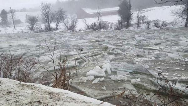
Ice and debris-jam flood
In areas that experience seasonal melting, if this is rapid ice floes can accumulate in rivers, forming constrictions and damming flows, causing river levels to rise upstream of the ice jam. A sudden release of the “ice jam” can cause a flood wave similar to that caused by a dam break to move downstream. Both meltwater and heavy rainfall in steep areas can cause landslips and debris flows. As these move downstream, major constrictions can build up. When these collapse or are breached, severe flooding can result. Both of these phenomena are very difficult to predict (source: Manual on flood forecasting and warning, WMO-No.1072).
Ice storm
Intense formation of ice on objects by the freezing, on impact, of rain or drizzle (source: International Meteorological Vocabulary, WMO-No. 182).
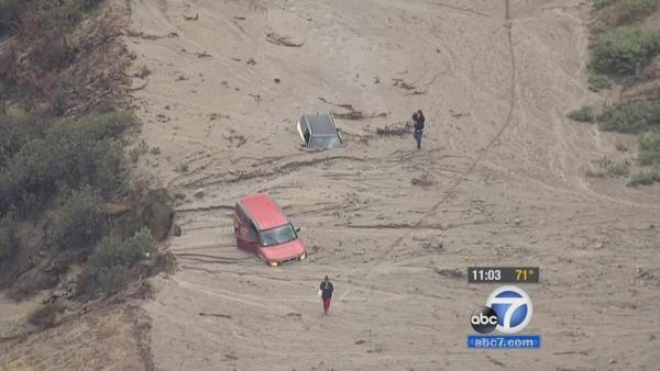
Landslide/Mudslide
Rapid movement of a mass of soil, rock or debris downhill by gravity, often assisted by water when the material is saturated (source: CCL TT-DEWCE).
Meteorological drought
Prolonged absence or marked deficiency of precipitation (source: International Glossary of Hydrology, WMO-No. 385).
Mudflow
Flow of water so heavily charged with sediment and debris that the flowing mass is thick and viscous (source: International Glossary of Hydrology, WMO-No. 385).
Multiple event flood
These result from heavy rainfall associated with successive weather disturbances following closely after each other. On the largest scale, these include for example floods in the Indo- Gangetic plains and central Indian regions often caused by the passage of a series of low- pressure areas or depressions from the Bay of Bengal, more or less along the same path. Multiple event floods can also affect large basins in mid-latitude areas in winter, when sequences of active depressions occur, for example over Western Europe (source: Manual on flood forecasting and warning, WMO-No. 1072).
Polluted air
Air containing dust, smoke, micro-organisms or gases different from those which normally compose it (source: International Meteorological Vocabulary, WMO-No. 182).
Sand haze
Haze caused by the suspension in the atmosphere of small sand or dust particles, raised from the ground prior to the time of observation by a sandstorm or dust storm (source: International Meteorological Vocabulary, WMO-No. 182).
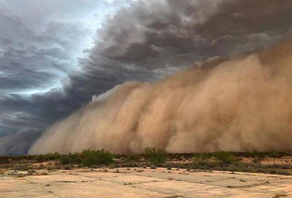
Sand storm
An ensemble of particles of sand energetically lifted by a strong and turbulent wind. The forward portion of the sandstorm may have the appearance of a wide and high wall. The height to which sand is raised will increase with increasing wind speed and instability (source: Aerodrome Reports and Forecasts, A Users’ Handbook to the Codes, WMO-No. 782).
Seasonal flood
These are floods that occur with general regularity as a result of major seasonal rainfall activity. The areas of the world subject to a monsoonal type climate are typically the areas most affected and critical situations arise when “normal” flooding is replaced by extended or high-runoff floods. Flooding is frequently a basin-wide situation that can last for periods of several weeks. Within active monsoon conditions, a number of individual peak events can occur during a flood season. Seasonal floods can also result from high water levels in lakes in the upper reaches of a river basin, for example Lake Victoria and the River Nile. Another type of seasonal flood can result from wet conditions in an upper portion of a catchment, which experiences a different climate regime from the lower, affected areas. The Nile and Yangtze rivers are good examples (source: Manual on flood forecasting and warning, WMO- No. 1072).
Single event flood
This is the most common type of flooding, in which widespread heavy rains lasting several hours to a few days over a drainage basin results in severe floods. Typically, these heavy rains are associated with cyclonic disturbances, mid-latitude depressions and storms, with well-marked synoptic scale frontal systems (source: Manual on flood forecasting and warning, WMO-No. 1072).
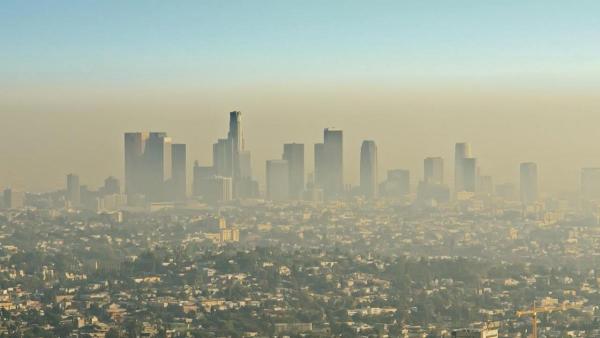
Smog
Fog having a high pollution content (from SMoke and fOG) (source: International Meteorological Vocabulary, WMO-No. 182).
Snowmelt flood
Significant flood rise in a river caused by the melting of snowpack accumulated during the winter (source: International Glossary of Hydrology, WMO-No. 385).
Snowstorm
Meteorological disturbance giving rise to a heavy fall of snow, often accompanied by strong winds (source: International Meteorological Vocabulary, WMO-No. 182).
Squall
Atmospheric phenomenon characterized by an abrupt and large increase of wind speed with a duration of the order of minutes which diminishes rather suddenly. It is often accompanied by showers or thunderstorms (source: International Meteorological Vocabulary, WMO-No.182).
Storm
An atmospheric disturbance involving perturbations of the prevailing pressure and wind fields, on scales ranging from tornadoes (1 km across) to extratropical cyclones (2000-3000 km across). Wind with a speed between 48 and 55 knots (Beaufort scale wind force 10) (source: International Meteorological Vocabulary, WMO-No. 182).
![]()
Storm surge
The difference between the actual water level under influence of a meteorological disturbance (storm tide) and the level which would have been attained in the absence of the meteorological disturbance (i.e. astronomical tide) (source: International Meteorological Vocabulary, WMO-No. 182).
Strong gale
Wind with a speed between 41 and 47 knots (Beaufort scale wind force 9) (source: International Meteorological Vocabulary, WMO-No. 182).
Sulphur rain
Rain coloured yellow by particles of pollen, yellow dust, etc. (source: International Meteorological Vocabulary, WMO-No. 182).
Thunderstorm
Sudden electrical discharges manifested by a flash of light (lightning) and a sharp or rumbling sound (thunder). Thunderstorms are associated with convective clouds (Cumulonimbus) and are, more often, accompanied by precipitation in the form of rain showers or hail, or occasionally snow, snow pellets, or ice pellets (source: International
Meteorological Vocabulary, WMO-No. 182).
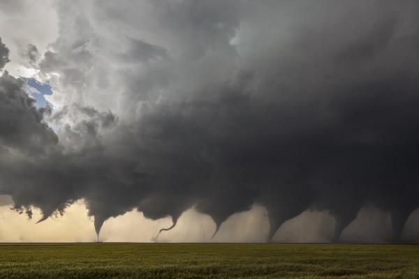
Tornado
A violently rotating storm of small diameter; the most violent weather phenomenon. It is produced in a very severe thunderstorm and appears as a funnel cloud extending from the base of a Cumulonimbus to the ground (source: CCL TT-DEWCE).
Tropical cyclone
Generic term for a non-frontal synoptic scale cyclone originating over tropical or sub-tropical waters with organized convection and definite cyclonic surface wind circulation. Tropical disturbance: light surface winds with indications of cyclonic circulation. Tropical depression: wind speed up to 33 knots. Tropical storm: maximum wind speed of 34 to 47 knots. Severe tropical storm: maximum wind speed of 48 to 63 knots. Hurricane: maximum wind speed of 64 knots or more. Typhoon: maximum wind speed of 64 knots or more. Tropical cyclone (South-West Indian Ocean): maximum wind speed of 64 to 90 knots. Tropical cyclone (Bay of Bengal, Arabian Sea, South-East Indian Ocean, South Pacific): maximum wind speed of 34 knots or more (source: International Meteorological Vocabulary, WMO-No. 182).
Tropical storm
A well-organized tropical cyclone in which the maximum average surface wind (one-minute mean) is in the range 63-118 km/h (39-73 mph) (34-63 knots) inclusive (source: Hurricane Operational Plan, Report No. TCP-30, WMO-TD No. 494).

Tsunami
A rapidly moving and often large sea wave generated by submarine earthquakes, landslides or volcanic activity (source: Manual on marine meteorological services, WMO-No. 558, App.1.2).
Typhoon
Name given to a tropical cyclone with maximum sustained winds of 64 knots or more near the centre in the western North Pacific (source: International Meteorological Vocabulary, WMO-No. 182).
Wet spell
A period of a number of consecutive days on each of which precipitation exceeding a specific minimum amount has occurred (source: International Meteorological Vocabulary, WMO-No. 182). A period of at least five consecutive days with daily precipitation exceeding 1 millimeter (source: CCL TT-DEWCE). Revised by the WMO Commission for Climatology Task Team on Definition of Extreme Weather and Climate Event (CCL TT-DEWCE).
II. Geo-physical
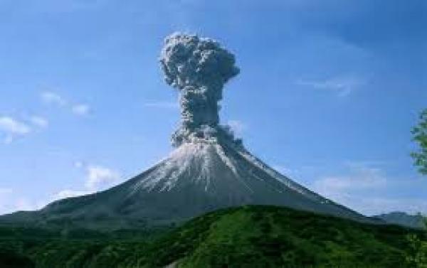
Volcanic ash
Atmospheric dust or particles varying considerably in size, originating from active volcanoes. The small particles often penetrate the stratosphere and remain suspended for a long period. Larger particles remain within the troposphere and can be carried by the wind to different regions of the Earth. Scavenging by rainfall and gravity eventually leads to the removal of volcanic ash from the atmosphere. Larger particles, or a concentration of smaller ones, can considerably damage aircraft, including their engines (source: Aerodrome Reports and Forecasts, A Users’ Handbook to the Codes, WMO-No. 782).
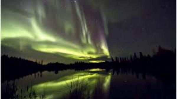
III. Space weather
Hazardous space weather situations can result of eruptive solar events consisting of Solar Flares and Erupting Prominences, Coronal Mass Ejections, associated streams of charged particles and high-speed particle streams from Coronal Holes. These eruptions are driving geomagnetic storms, ionospheric storms, and radiation storms in near-Earth space, with hazardous impacts.
Geomagnetic storms
Geomagnetic storms, which are caused primarily by CMEs or by high-speed particle streams interacting with the magnetosphere, are strong temporary disturbances of the Earth’s magnetic field. Geomagnetic storms can last several hours. They may cause major damage to power grids through geo-magnetically induced currents (GIC). Geomagnetic storms and disturbances are highly variable in space and time (source: The potential role of WMO in space weather, WMO/TD-No. 1482).
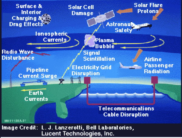
Ionospheric storms
Turbulence in the F region of the ionosphere, usually due to a sudden burst of radiation from the Sun (source: International Meteorological Vocabulary, WMO-No. 182).
Radio blackout
X-ray and EUV bursts from a solar flare cause an ionization, increasing the number of free electrons, in the atmosphere below 90 km on the sunlit side of the Earth. The enhanced electron density increases the amount of radio energy lost as radio waves pass through this region. During a large flare event the amount of radio energy lost is sufficient to make the return signal from the ionosphere too small to be useful with normal radio receivers. The net effect of this process is the radio blackout – no signal – for HF transmissions. Radio blackouts primarily affect HF (3-30 MHz) although detrimental effects may spill over to VHF (30-300 MHz) and beyond in fading and diminished ability for reception (source: The potential role of WMO in space weather, WMO/TD-No. 1482).
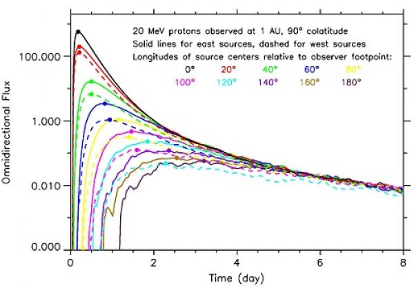
Solar energetic particles
A Solar Energetic Particles event (SEP) is a sudden release of particles (protons, electrons and heavy ions) with energy ranging from a few tens of keV to GeV. These events are generally associated with Solar Flares or Coronal Mass Ejections. High-speed particle streams, in particular electrons, are also emitted by Coronal Holes, which are persistent large-scale features of the solar corona that appear dark in EUV and X-ray images (source: The potential role of WMO in space weather, WMO/TD-No. 1482).
Solar flares
Bright eruption from the Sun's chromosphere. Solar flares are classified in terms of the area of chromosphere affected, the duration of the phenomenon, and the width of the Hα line of hydrogen, on a scale ranging from 1- (minor eruption) to 3+ (very large eruption) (source: International Meteorological Vocabulary, WMO-No. 182).
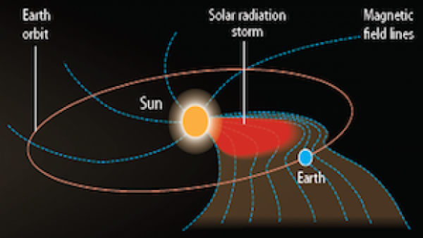
Solar radiation storm
Solar radiation storms occur when large quantities of charged particles, primarily protons, accelerated by eruptive processes at or near the Sun are reaching the near-Earth environment.The Earth’s magnetic field and atmosphere generally protect from this particle radiation, but that shielding depends on latitude, magnetic field strength and direction. In the Polar Regions the magnetic field lines intersecting the Earth's surface allow the particles to penetrate into the atmosphere. Solar radiation storms thus often take the form of Polar Cap Events (PCA), which occur in limited areas around geomagnetic poles; they may last more than a week. A factor of criticality of a radiation storm is the energy spectrum of the solar protons. High- energy protons cause single event upsets in spacecraft or aircraft electronics and increase the harmful radiation dose of exposed human beings, e.g. in manned spaceflights or cross- polar aircraft flights. Lower energy protons have a severe impact on the polar ionosphere and affect HF propagation at high latitude. The severity of radiation storms can thus be characterized by the flux of charged particles (typically in 5-minute average) above a given energy threshold such as 10 or 100 MeV. For example the NOAA scale characterizes a radiation storm as extreme when the 5-min flux above 10 MeV exceeds 105 particles•s-1•sr-1•cm-2. In large magnitude solar eruptions, high-energy events may last only a few hours while low-energy events may last up to one week (source: The potential role of WMO in space weather, WMO/TD-No. 1482).
Πηγή : WMO
Θοδωρής Ν. Κολυδάς